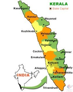
Kerala is a state on the Malabar Coast of India. It was formed on 1 November 1956, following the passage of the States Reorganisation Act, by combining Malayalam-speaking regions of the erstwhile regions of Cochin, Malabar, South Canara, and Travancore. Spread over 38,863 km2 (15,005 sq mi), Kerala is the 21st largest Indian state by area. It is bordered by Karnataka to the north and northeast, Tamil Nadu to the east and south, and the Lakshadweep Sea to the west. With 33 million inhabitants as per the 2011 census, Kerala is the 13th-largest Indian state by population. It is divided into 14 districts with the capital being Thiruvananthapuram. Malayalam is the most widely spoken language and is also the official language of the state.
TRANSPORT AIRPORT: Kollam Airport, established under the Madras Presidency, but since closed, was the first airport in Kerala.Kannur had an airstrip used for commercial aviation as early as 1935 when Tata airlines operated weekly flights between Mumbai and Thiruvananthapuram – stopping at Goa and Kannur. Trivandrum International Airport, managed by the Airport Authority of India, is among the oldest existing airports in South India. Calicut International Airport, which was opened in 1988, is the second-oldest existing airport in Kerala and the oldest in the Malabar region. Cochin International Airport is the busiest in the state and the seventh busiest in the country. It is also the first airport in the world to be fully powered by solar energy and has won the coveted Champion of the Earth award, the highest environmental honour instituted by the United Nations. Cochin International Airport is also the first Indian airport to be incorporated as a public limited company; it was funded by nearly 10,000 non-resident Indians from 30 countries. Other than civilian airports, Kochi has a naval airport named INS Garuda. Thiruvananthapuram airport shares civilian facilities with the Southern Air Command of the Indian Air Force. These facilities are used mostly by central government VIPs visiting Kerala. RAILWAY: Southern Railway zone of Indian Railways operates all railway lines in the state connecting most major towns and cities except those in the highland districts of Idukki and Wayanad.[387] The railway network in the state is controlled by two out of six divisions of the Southern Railway; Thiruvananthapuram Railway division and Palakkad Railway Division.[388] Thiruvananthapuram Central (TVC) is the busiest railway station in the state. MAJOR RAILWAY STATION #Thiruvananthapuram Central (TVC) # Ernakulam Junction (South) (ERS) #Kozhikode (CLT) #Kollam Junction (QLN) #Thrissur (TCR) #Palakkad Junction (PGT) #Kannur (CAN) #Shoranur Junction (SRR) #Ernakulam Town (North) (ERN) #Kottayam (KTYM) #Chengannur (CNGR) #Alappuzha (ALLP) #Kochuveli (KCVL) #Kayamkulam Junction (KYJ) #Tirur (TIR) #Kasaragod (KGQ) #Aluva (AWY) #Thalassery (TLY) ROAD: Kerala has 331,904 kilometres (206,236 mi) of roads, which accounts for 5.6% of India's total. This translates to about 9.94 kilometres (6.18 mi) of road per thousand people, compared to an average of 4.87 kilometres (3.03 mi) in the country. Roads in Kerala include 1,812 kilometres (1,126 mi) of national highway; 1.6% of the nation's total, 4,342 kilometres (2,698 mi) of state highway; 2.5% of the nation's total, 27,470 kilometres (17,070 mi) of district roads; 4.7% of the nation's total, 33,201 kilometres (20,630 mi) of urban (municipal) roads; 6.3% of the nation's total, and 158,775 kilometres (98,658 mi) of rural roads; 3.8% of the nation's total.Kottayam has the maximum length of roads among the districts of Kerala, while Wayanad accounts for minimum.Most of Kerala's west coast is accessible through the NH 66 (previously NH 17 and 47); and the eastern side is accessible through state highways
KERALA MAP