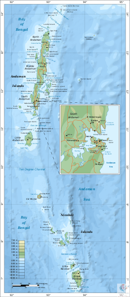
The Andaman and Nicobar Islands is a union territory of India consisting of 572 islands, of which 37 are inhabited, at the junction of the Bay of Bengal and the Andaman Sea. The territory is about 150 km (93 mi) north of Aceh in Indonesia and separated from Thailand and Myanmar by the Andaman Sea. It comprises two island groups, the Andaman Islands (partly) and the Nicobar Islands, separated by the 150 km wide Ten Degree Channel (on the 10°N parallel), with the Andaman islands to the north of this latitude, and the Nicobar islands to the south (or by 179 km). The Andaman Sea lies to the east and the Bay of Bengal to the west. The island chains are thought to be a submerged extension of the Arakan Mountains.
The territory's capital is the city of Port Blair. The total land area of the islands is approximately 8,249 km2 (3,185 sq mi). The territory is divided into three districts: the Nicobar District with Car Nicobar as its capital, the South Andaman district with Port Blair as its capital, and the North and Middle Andaman district with Mayabunder as its capital.
TRANSPORT
AIRPORT:The only civil airport of the Andaman and Nicobar Islands is Veer Savarkar International Airport near Port Blair. It has regular flights to Chennai, Kolkata, New Delhi, Bangalore, and Visakhapatnam. From 2016 onwards, night flights were also operated along with the day flights.
WATERWAY:
Another mode of transport is ship which has routes from Chennai, Kolkata and Visakhapatnam. The journey takes approximately three days and two nights.