Himachal Pradesh

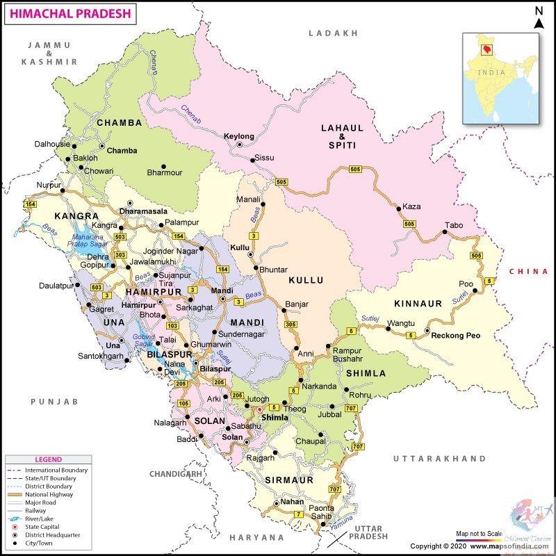
Himachal Pradesh "Province of the Snow laden Mountains" is a state in the northern part of India. Situated in the Western Himalayas, it is one of the thirteen mountain states and is characterized by an extreme landscape featuring several peaks and extensive river systems. Himachal Pradesh is the northernmost state of India and shares borders with the union territories of Jammu and Kashmir and Ladakh to the north, and the states of Punjab to the west, Haryana to the southwest, Uttarakhand to the southeast and a very narrow border with Uttar Pradesh to the south. The state also shares an international border to the east with the Tibet Autonomous Region in China. Himachal Pradesh is also known as Dev Bhoomi, meaning 'Land of God' and Veer Bhoomi which means 'Land of Braves

HIMACHAL PRADESH MAP

Transport AIRPORT Himachal has three Domestic Airports in Kangra, Kullu and Shimla districts. The air routes connect the state with Delhi and Chandigarh. Bhuntar Airport is in Kullu district, around 10 kilometres (6 mi) from district headquarters. Gaggal Airport is in Kangra district, around 15 kilometres (9 mi) from district headquarters at Dharamshala, which is around 10 kilometres from Kangra Shimla Airport is around 21 kilometres (13 mi) west of the city. RAILWAY Kalka-Shimla Railway Broad-gauge lines The only broad-gauge railway line in the whole state connects Amb Andaura–Una Himachal railway station to Nangal Dam in Punjab and runs all the way to Daulatpur, Himachal Pradesh. It is an electrified track since 1999. While a tiny portion of line adjacent to Kandrori(KNDI) station on either side on Pathankot-Jalandhar Section, under Ferozepur Division of Northern Railway also crosses into Himachal Pradesh, before venturing out to Punjab again. Future constructions: Una Himachal–Hamirpur rail project via Dhundla Bhanupali (Punjab)–Bilaspur, Himachal Pradesh Chandigarh–Baddi Kangra Valley Railway Narrow-gauge lines Himachal is known for its narrow-gauge railways. One is the Kalka-Shimla Railway, a UNESCO World Heritage Site, and another is the Kangra Valley Railway. The total length of these two tracks is 259 kilometres (161 mi). The Kalka-Shimla Railway passes through many tunnels and Bridgies, while the Pathankot–Jogindernagar meanders through a maze of hills and valleys. The total route length of the operational railway network in the state is 296.26 kilometres (184.09 mi). ROADS A section of NH 5 in Kinnaur Roads are the major mode of transport in the hilly terrains. The state has road network of 28,208 kilometres (17,528 mi),including eight National Highways (NH) that constitute 1,234 kilometres (767 mi) and 19 State Highways with a total length of 1,625 kilometres (1,010 mi). Hamirpur district has the highest road density in the country. Some roads are closed during winter and monsoon seasons due to snow and landslides. The state-owned Himachal Road Transport Corporation with a fleet of over 3,100,operates bus services connecting important cities and towns with villages within the state and also on various interstate routes. In addition, around 5,000 private buses ply in the state.

Open chat
Hi, how can I help you?